Degradation Reduction
Degradation and REDD+
Reducing emissions from forest degradation is one of the REDD+ activities, which means it qualifies for financial support under the international architecture for REDD+. Detecting and curbing it, however, requires more refined monitoring and operational capabilities than for clearcutting. Brazil is currently developing such capabilities, so that in the future it can present measurable, reportable and verifiable results on reducing emissions from forest degradation.
The degradation process
Deforestation is a process that completely removes the forest cover from a portion of land, converting forests into a clearcut area. The process often starts with hardwood logging and moves on to logging of less valuable wood, for building or plywood and board production. This process can last a few years, because it is carried out by different groups, with different logging interests. The logging activities do not remove all the trees in the terrain, leaving behind trees that hinder the detection of deforestation through monitoring systems.
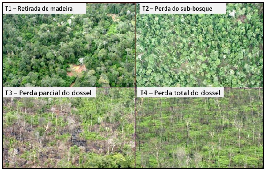
It is common practice to introduce grasses in these areas, for cattle ranching. The grass and remaining trees are more fire prone, 10% to 20% of the trees that make up the canopy can endure the recurrent fires with several dead trees standing beside. The grasses are more fire resilient and sprout again soon after, allowing the grazing to resume.
Degradation monitoring in Brazil
In 2008, INPE has developed the DEGRAD system to track the increase in forest degradation that had been detected by the DETER system. DEGRAD monitors areas in the deforestation process, where the forest cover has not been fully removed. The objective of this system is to map out in detail the forest areas that tend to be converted to clearcutting. The process consists of preparing the satellite images by applying highlights contrast to underscore the evidence of degradation. The degraded areas are then mapped individually, they are not accounted by PRODES.
Detecting changes between the extremes of the gradient is the challenge for monitoring systems such as DETER, DEGRAD and PRODES. These changes are often not conspicuous, especially if they are in the early stages, when the forest canopy has not been considerably altered and the signs of bare soil are still slight. Due to the spatial resolution of satellite images, it is difficult to identify the occurrence of degradation before the cutting reaches 50% of the canopy.
Redes Sociais